The Charles River and the South Natick Dam
South Natick and Charles River development, from the Atlas of Middlesex County (Natick Historical Society collection)
The Charles River was a focal point of daily life and social interaction among Eastern Woodlands people long before Europeans arrived to plant their Massachusetts colonies in the early 17th century. From the pre-colonial era to today, the Charles has flowed from Hopkinton to Boston. Like other principal rivers in New England, it has been a home for wildlife, a landmark of natural beauty, a hub for trade, industry, and economic development, and an indispensable element of recreation, settlement, and agriculture. The appealing bend in the river in South Natick was selected by Massachusett and Nipmuc people and the Rev. John Eliot to become the first “Praying Indian” town in eastern Massachusetts.
Early English colonists industrialized the Charles River. The first dam near the South Natick meetinghouse was built in 1720 by John Sawin, whose family operated grist mills and sawmills for several decades. From the mid-18th century through to the 19th century, several mill operators maintained dams and water-powered mills near the site of the present dam.
In South Natick, the original channel of the river hugged the north shore. A flood in 1808 cut a second channel at the south bank and created the small island (Horace Holyoke Island) today. A new elongated two-part dam structure, with the island connecting them, was in place until the current dam was installed in 1935.
1874 map of industrial and residential structures near the South Natick dam (by Levanthal).
There is almost no sign today of the extensive commercial and industrial activity historically tied to South Natick's river. For more than 50 years (1778-1831), Deacon William Bigelow and his sons, Isaac and Abraham, operated a commercial complex—including a grist mill, sawmill, and paper mill—surrounding the Pleasant Street bridge (initially built in 1651 by the “Praying Indians”). The Bigelow dams were rebuilt in 1808 and 1815 to repair ice and flood damage.
From 1838 to 1858, Alan C. Curtis expanded the water-powered mill complex and added wool carding machinery to prepare wool for making cloth. He had two operations on the south bank, including a man-made mill canal and one mill that was the last manufacturing facility on the north shore in South Natick.
For decades, from 1885 to 1930, there was an active era of productive industry at the South Natick Dam site. In 1890, the Eliot Falls Electric Company supplied electricity for streetlights in Natick, Wellesley, and surrounding towns. However, the site wasn’t profitable, and there were concerns about depleting the “mill pond” upstream from the dam, so the power station was abandoned in 1901. Manufacturing firms in South Natick later included the Boston Rubber Cement Company, Boston Bedding Supply (renamed Eliot Mills, Inc.), Indian Spinning Mills, Inc., and Stewart Manufacturing Co. (from 1919 to 1929).
For more than 100 years, the Charles River in South Natick has been a preferred site for outdoor recreation, especially boating and fishing. A 1908 magazine article praised the Charles as offering “a greater pleasure to a greater number of people than any other river stretch of equal length in America.” In the early 20th century, the mill pond above the spillway was a popular site for picnicking and Natick’s first “swimming hole,” with a boathouse near Eliot Street and Badger Avenue. It continues to be a scenic attraction offering birding and wildlife viewing opportunities, particularly near Mass Audubon’s Broadmoor Wildlife Sanctuary upstream from the dam.
Sketch of the South Natick dam site, late 1800s (Natick Historical Society collection)
The dam's history has been marked by repeated floods, dangerous ice flows, and spring freshets, threatening to destabilize the dam and surrounding properties. The first recorded dam failure occurred in the winter of 1807 when river ice broke through it. On February 16th, 1886, massive flooding on the Charles threatened the dam, the Pleasant Street bridge, and downstream properties. Men worked hard to plug the breaches of the spring flooding that stood as a high water record for 40 years.
The north section of the dam failed in 1917, and the flood surge carried away the arches of the bridge. In April 1929, severe Nor’easter flooding breached the dam, and high water inundated downstream properties, extending 100 yards on each side of the river. Disaster struck again in 1932 when the dam was once again destroyed, and the low water level exposed a reputed “Indian bridge”—a series of large stepping stones that Eastern Woodland people may have used to cross the river in precolonial times—located less than a mile above the dam. In response to this last failure, the current dam at South Natick was built. A special town meeting in 1933 got the ball rolling to start building the dam that exists today.
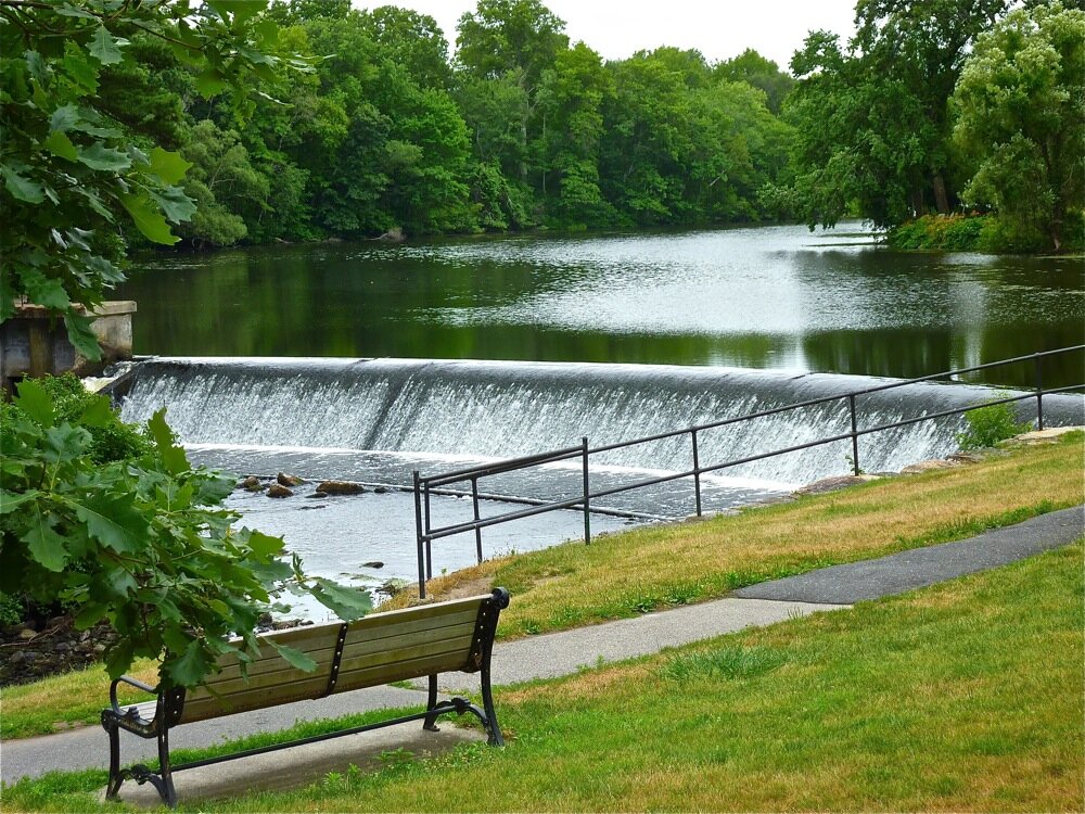
Reconstruction aimed to beautify the riverside and nearby Old Town Park, create a new swimming spot, and put men to work during the Great Depression. The water-powered industry was no longer a consideration. Despite the $35,000 estimated cost (about $670,000 in 2020 dollars), 800 town meeting voters unanimously approved the project in March 1934, and town employees offered to give 7.5 percent of their annual wages to help pay for it. The new dam—135 feet long, 20 feet wide, and 12 feet high, sitting on solid rock—was essentially finished by the end of the summer. Some federal aid was secured; ultimately, more than 200 men and women worked on the project, costing about $50,000. Nearly 3,000 people gathered for the dedication, and speakers praised the dam as a “national shrine.”
Today, the 86-year-old dam requires renovation, including remediation of the earthen embankment at the south end of the dam on the border of a pleasant wooded picnic area. In December 2019, the proposed renovation work was put on hold so a complete removal of the spillway could be studied. Removal would end the threat of dam failure, eliminate maintenance costs, help to re-establish natural wetland and flood plains on either shore, improve fish passage, provide expanded habitat for wildlife, and reduce the frequency of harmful algae blooms in the mill pond. Upgrading the dam would preserve one of the town’s iconic landmarks as the centerpiece of a picturesque and popular park. Many residents cherish their past and present experiences of playing in the park, fishing near the dam, picnicking under the nearby pine trees, and even having wedding photos taken at the spillway.
The Charles River in South Natick has experienced periods of rapid settlement and development, economic booms and busts, droughts and floods, and eras characterized by agriculture, manufacturing, and recreation. The dam may be renovated, or a free-flowing riparian habitat may be restored, but the future of this site will inevitably be profoundly shaped by its rich and extensive history.
By: Charlotte Diamant
1934 newspaper reports of the dedication of the new South Natick dam


Read a linked story about Charlotte Diamant and the South Natick Dam research on our Community History pages, click here.
Charlotte Diamant is a student at Wellesley College, majoring in Environmental Studies. She did extensive research and wrote a fully detailed history of the South Natick dam, click here for her report.
